10 Feb 2020
Rural electrical grid project wins UKRI Citizen Science Exploration Grant
Project aims to engage citizen scientists in labeling rural and remote homes in satellite imagery

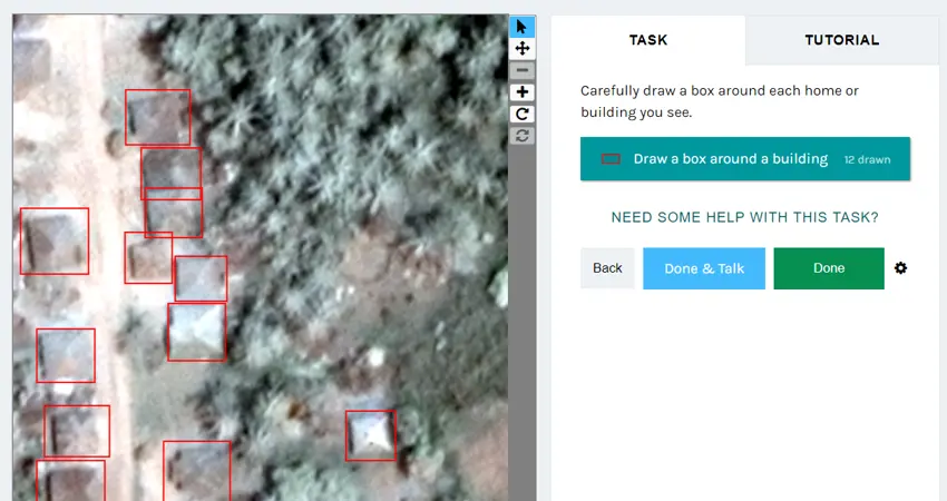
The citizen science labelling platform
There are close to one billion people worldwide without access to electricity, many of which live in rural sub-Saharan Africa, however the UN is targeting affordable clean energy access for all by 2030.
To help close this gap, the Geospatial Design of Energy Systems for Africa (GeoDESA) project, led by Professor Malcolm McCulloch and a team of Oxford researchers, aims to integrate citizen science in rural electrical grid planning for developing regions and provide novel electrification strategies targeted to the specific needs of rural communities. The project is one of 53 UKRI-funded projects worth £1.4m that will enable members of the public to actively contribute to research and innovation projects that affect their lives.
One key challenge in planning electrical grids is the need for detailed home location data, which are necessary to design grid topologies and architectures. Gathering data using conventional survey methods is a laborious and expensive process and currently available home location datasets, such as OpenStreetMap, are typically incomplete, particularly in the hardest-to-reach rural poor areas.
High-resolution satellite imagery and modern computer vision algorithms can fill the gaps in these datasets and speed up the process. While many algorithms have been trained to detect housing in the past, they are typically based on rich urban contexts. The full diversity of rural and remote housing styles must be taken into account to enable the dwelling detection needed for electrification design.
By engaging citizen scientists fluent in local rural housing styles in the labelling of homes in satellite imagery, local knowledge can be incorporated. Labelled images will be used to train object-detection AI algorithms to find a full range of diverse rural housing styles in the hardest to reach areas, allowing grids to be efficiently designed to suit community needs. The resulting detailed, up-to-date mapping of homes can be analysed alongside meteorological and socio-economic geospatial datasets in GIS to produce cost-optimised, community-tailored grid designs for rural unelectrified contexts.
Alycia Leonard, Data Analysis and Management lead on the project, says, “Local perspectives are critical in designing electrical systems that work for each community. Through these kinds of citizen science efforts, we can bring diverse perspectives to the electrification problem - and the data. We can incorporate local perspectives in a scalable, data-driven design approach, which is really exciting".
The project complements past and ongoing work undertaken at the University of Oxford in rural Africa electrification in the SONG and RELCON projects. The methods developed and data generated will be useful for electrical system planning in many rural and remote contexts, and can cross-apply into other geographic planning disciplines, such as urban planning, migration tracking, and geospatial poverty estimation.
Outreach activities and workshops alongside the online citizen science platform will engage the general public in labelling homes in satellite imagery, integrate local knowledge in electrical system planning, evaluate the benefits of citizen science in this area, and develop training sets of rural housing styles for future computer vision algorithms.
UKRI reports, “The projects will target communities who would not normally engage with research and innovation, so they can shape research and innovation that is relevant to their lives and their local areas. This will expand the opportunities for people from across the UK to actively contribute to publicly funded research and encourage underserved communities to share their ideas, concerns and aspirations and to get involved in decision making. The projects also aim to inspire a new generation of children and young people about the wonder and potential of research and innovation”.


